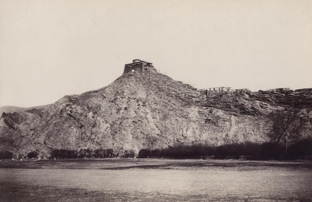
Medicine King Mountain (Part 1): From the Past to the Future
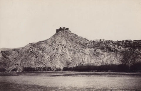
Taken between 1900 and 1901, held at the Library of Congress in the United States
Photographed by Norzunov and Chuebikov
(Both from Buryatia)
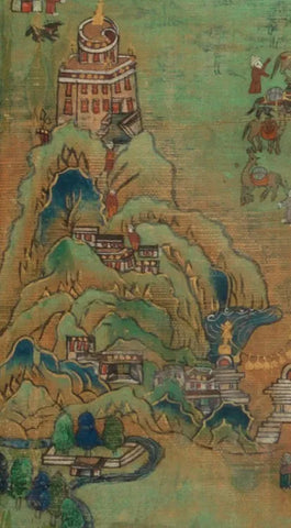
19th century, in the collection of the Rubin Museum
It is generally believed to have been commissioned by pilgrims from North Asia
Details: Mount Yarlha Shampo in Lhasa and its architectural complex
Lhasa Medical College - Meditation Caves - Chakar Lhakhang Monastery
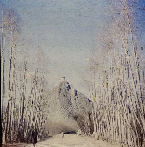
From the first half of the 20th century, in the collection of the Oxford Peter Rivers Museum
Photographed by the team of Li Jisheng (1905-2000)
Preface
Compassionately pitying all beings with bad karma,
Hearing the cries, extinguishing the suffering of evil realms,
Dispelling all poisons with the Medicine Buddha,
I bow before the radiant light of the Medicine Buddha.
(Translation of Medicine Buddha Praise)
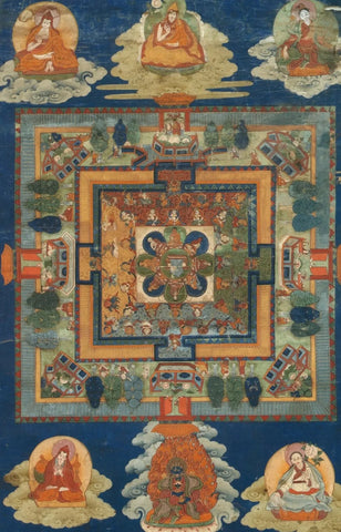
"Medicine Buddha Altar City"
In the mid-18th century, collected by the Hahn Cultural Foundation
Gathering a variety of medicinal herbs and sacred sites of various healing masters throughout history
There is a saying in Lhasa that goes: "There are famous doctors everywhere, but they all gather at Medicine King Mountain." Since the end of the 17th century, Medicine King Mountain and its architectural complex have been one of the most important landmarks in Lhasa. During the Tubo period, one of the wives of King Songtsen Gampo, Princess Ruyongsa(མི་ཉག་རུ་ཡོང་བཟའ་) from the Muya region, built a temple at the foot of the mountain. Historical records refer to it as Charagunbu Temple or Chara Jixiang Wuliang Palace, but the locals prefer to call it Charalüp Temple. Here, "Chara" refers to the main deity of the temple's cliff carvings, and "Lup" signifies that this was originally the dwelling place of local spirits (this is a topic of debate in academic circles).
During the Tubo period, there was an iron chain connecting Medicine King Mountain and Red Mountain, a spectacular sight indeed! People designated the Red Mountain where the Potala Palace is located, the Mopan Mountain where the Ganden Monastery is located, and Medicine King Mountain as the soul mountains of Avalokiteshvara, Manjushri, and Vajrapani respectively. After the collapse of the empire, Medicine King Mountain and the Charalüp Temple at its foot became a place of seclusion for practitioners. According to historical records, practitioners who meditated here included Tang Dongjebu(ཐང་སྟོང་རྒྱལ་པོ་;1361-1485) and Jokhang Zubei Duopa Waiserwa Zenzan(དོལ་པོ་པ་;1292-1361). In the near future, this place would become a milestone in the history of Tibetan medicine.
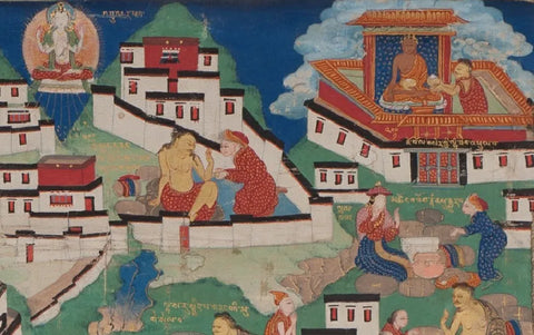
19th century, works in the Eastern Tibetan area
Detail: Seeing Guanyin Bodhisattva on Mount Yaowang - Praying at the Jokhang Temple to end famine
(Note: The title and description are translated from Chinese to English)
What truly makes the world remember the Medicine King Mountain is the famous medical college in the Tibetan area, known as the "Exquisite Wisdom Island of Lapis Lazuli Light Benefiting All Viewers" (བཻཌཱུརྻ་འགྲོ་ཕན་ལྟ་ན་ངོ་མཚར་རིག་བྱེད་གླིང་) built under the supervision of Regent Desi Sangye Gyatso (1653-1705). On the foundation of a temple built by Tang Dongjiebu, Desi expanded the main hall with over twenty columns, a hall layout reminiscent of a palace town plan, cleverly designed mountain paths, and scattered cliff carvings in the mountains, creating the well-known architectural complex of Medicine King Mountain (First Phase: between 1695 and 1697). With Desi proclaiming the general rules of the "Four Medical Classics" to the students on May 25, 1697, the institution heralded a new era in Tibetan medicine history.
During the time of the Seventh and Eighth Regent Lamas, the Medicine King Mountain architectural complex underwent large-scale expansion, while the enrollment system, specific teaching arrangements, and daily medical training at the college were increasingly perfected. Here, medical experts and famous doctors from various parts of Tibet gathered. When they returned to their hometowns, they built countless medical colleges following the model of the Medicine King Mountain medical college. As the saying goes, "From one mother, many children, and the children all practice medicine." Under the leadership of the Thirteenth Regent, the Medicine King Mountain Medical College experienced its golden age. Through in-depth research on medical classics, the printing and development of related scriptures, and the establishment of personalized medical schools, the college has become the "Medicine Buddha Palace Town" as described by the Fifth Regent.
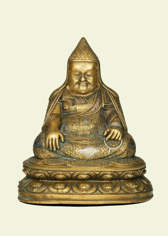
In the fifteenth century, the prestigious Jokhang Temple in Lhasa
"That slightly bulky sage"
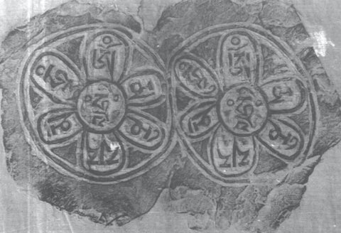
"Inscription on the Cliffside South of Medicine King Mountain in Lhasa: Six-Syllable Mantra"
From "Inscriptions on the Cliffside of Medicine King Mountain" (1996)
Main text
Lhasa is located on a vast plain surrounded by mountains reaching up to a thousand meters high. The Lhasa River flows east into the plain and then turns west along the southern foothills, eventually merging with the Yarlung Tsangpo River about forty kilometers away (see figure one). In the center of the plain, not far from the river, there is a small hill. This hill seems to have played an important role when the city was founded in the 7th century: the Red Hill, Medicine King Hill, and Grinding Disc Hill. The Red Hill and Medicine King Hill are both about one hundred meters higher than the plain, while the Grinding Disc Hill is only eighteen meters high. The Red Hill and Medicine King Hill are about one kilometer apart and are considered close neighbors in the complex landscape (see figures two and three). All three hills have caves.
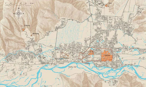
*Image 1: "Layout Map of Lhasa City in 1985"
Revised and redrawn by Knud Larsen in 2020
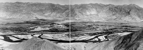
*Image 2: "Aerial View of Lhasa City from the South"
Taken by F. Spencer Chapman in 1936
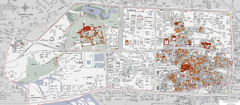
*Image 3: "Illustration of Ancient Buildings in the Lhasa Forest"
Drawn by Knud Larsen in 1999
Translation note: "Lingkhor" (གླིང་སྐོར་) - A pilgrimage route around the old Lhasa city
Legend has it that in the 7th century, King Songtsen Gampo practiced meditation here, and the Potala Palace was built on top of the caves on the mountain (as shown in Figure Four and Figure Five). It is generally believed that the great Tang Dongjiebu established a temple at the top of Mount Yaowangshan, which had a circular top. The regent Sangjie Jiacuo, after the fifth Dalai Lama, expanded the temple in 1696 and established a medical school there. In the 1980s, the ruins of the building were demolished.
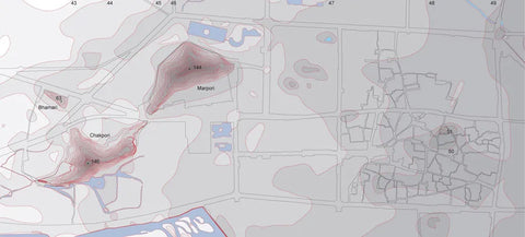
*Image 4: Topographic Map of Lhasa Lingkor
Drawn by Knud Larsen in 2000
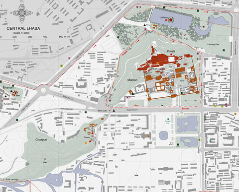
Drawn by Knud Larsen in 1999
The Potala Palace and the Medicine King Hill are the most important landmarks in Lhasa. Whether in the city or its surroundings, people can see this iconic combination of scenery. No matter where you are, just look up at the Potala Palace to determine your direction. In our "The Lhasa Atlas", we particularly emphasize the importance of experiencing the layout of the old city from the perspective of admiring the Potala Palace. Similarly, the Medicine King Hill and the Medical College play a similar role, which is emphasized by the construction of new roads.
Yutuo Road connects the entrance of the Jokhang Temple (Figure Six) with the Medicine King Hill (Figure Seven) through a visual axis. The Norbulingka Road is marked by the Medicine King Hill, with the view from the entrance of Norbulingka extending towards the Medicine King Hill (Figure Eight). The Red Mountain and the Medicine King Hill together form a natural "gate" leading to the old city of Lhasa. Therefore, there is an important visual interaction between the Potala Palace and the Medicine King Hill and Medical College (Figure Nine).
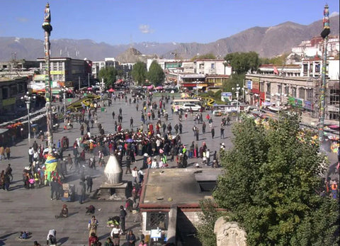
*Image 6: "View of Medicine King Mountain from the top of Jokhang Temple"
Taken by Knud Larsen in 2009
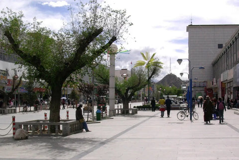
*Image 7: "View from Yutuoluo Road towards Yaowangshan"
Taken by Knud Larsen in 2009.
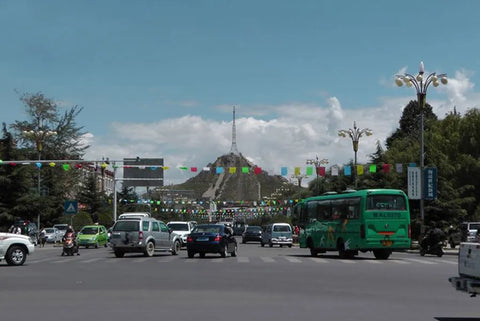
*Image 8: "View of Mount Yawang from the road to Roblinca"
Taken by Knud Larsen in 2009.
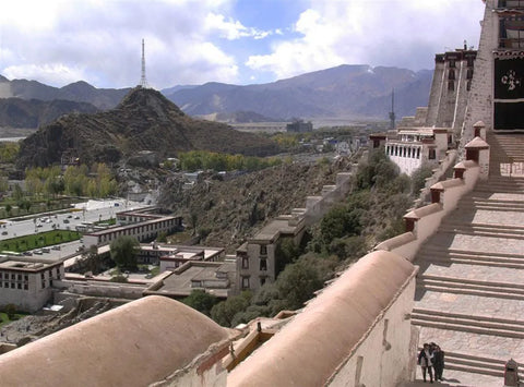
*Image 9: "View from the steps of the Potala Palace towards the Medicine Mountain"
Taken by Knud Larsen in 2009
By observing these two architectural complexes and assessing the distance between them, you can accurately determine your position in the environment. On the other hand, the act of connecting the two architectural complexes carries specific symbolic significance. The Medical Temple complex on the Medicine King Mountain serves as both a medical school and a temple. Monks receive education to become doctors, and they treat and research here. When residents need treatment, this is where they would go. Eventually, the local government established the Menzikang (Tibetan Hospital) in the old city. Therefore, for the residents living in Lhasa, the Medicine King Mountain holds an important position in both visual representation and practical function.
When we decided to reconstruct the architectural complex of Medicine King Mountain, it was necessary to first understand the basic layout of the complex. Before the 1950s, several Western photographers captured images of the Medical School on Medicine King Mountain and left behind photographs. These included Hugh Richardson, Frederick Spencer Chapman, Heinrich Harrer, C. S. Cutting, Josef Vanis, Charles Bell, Rabden Lepcha, Evan Nepan, and John Claude White. I found that only Josef Vanis' photograph (Image Ten) had enough detail. However, there was a serious problem, as all the good photos were taken from the same perspective (from the direction of the Potala Palace). Therefore, it was difficult to understand the three-dimensional structure of the architectural complex. Harrer's photograph was from the same direction as Vanis' photograph but from a further distance with less detail.
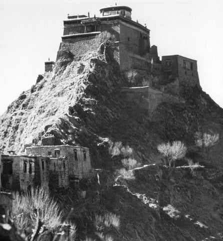
*Image 10: "Medical School on Medicine King Mountain in Lhasa"
Taken by Joseph Varnish in 1954
There is an architectural feature that is still clearly visible today: the remnants of two stone structures (see Image 11). These ruins can be easily identified in the photos of Wanis. One is the corner of a fortress supporting a passageway, while the other is the corner of an independent building, possibly a gateway leading to the entire complex (see Figures Twelve and Thirteen). An important detail in the photos of Wanis is the presence of a person standing on the roof and another standing at the main entrance of the temple (see Figure Ten). By using them as reference points, we can roughly estimate the length of the main entrance. However, it is very difficult to find reference points on the adjacent north facade. Assuming the main entrance is in the center of the east facade, and the center of the round tower is not in the center of the entire complex but closer to the west wall on the same axis, I speculate that there is a square building built on a steep hill, with a narrow top and a domed roof (for which I have drawn a plan).
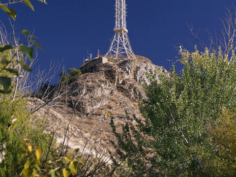
*Image 11: "Architectural Ruins of the Medical Academy on Medicine King Mountain"
Photographed by Knud Larsen in 2010
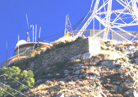
*Image 12: "Close-up of Architectural Ruins"
Captured by Knud Larsen in 2010.
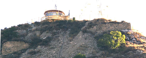
*Image 13: "Close-up of architectural ruins"
Taken by Knud Larsen in 2010
The photo clearly shows that the path to the medical college is a series of ramps and stairs starting from the north side, with the sidewalk extending deep below the main temple structure. The entrance ramp is constructed of heavy stone blocks and sharply turns upwards towards the gatehouse. The gatehouse appears to have two levels, with internal stairs leading to a narrow open space directly below the north facade of the temple. From the doors and windows on the north facade, there is a series of complex stairs leading to a narrow space underground, providing access to the entrance of the main hall. There is a possibly stepped long ramp encircling the northeast corner, leading upwards to the entrance of the main hall. At the entrance, there is a platform, where people are seen standing in the photo taken by Chapman. In the background of this famous photo, monks on the platform and the Red Mountain architecture complex can be seen.
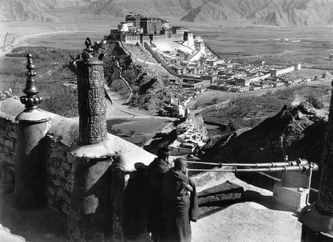
*Image 14: "View of Potala Palace from Medicine King Mountain"
Taken in 1937 by Spencer Chapman.
Based on my understanding of traditional Tibetan architecture, I have created a set of floor plans (Figure 15 to Figure 17) showing a prayer hall with numerous columns surrounding a more sacred circular space at the bottom of a tower. However, I am not sure about its specific function and location. Therefore, the floor plans are drawn from the outside towards the inside, and the subsequent floor plans will be designed and drawn from the inside out.
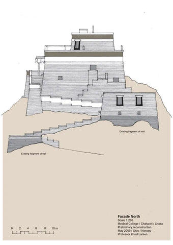
*Image 15: "Preliminary Restoration Drawing of Medicine King Mountain: North Facade"
Drawn by Knud Larsen in 2009
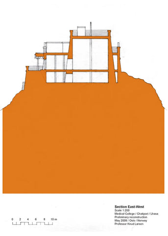
*Image 16: "Preliminary Restoration of Medicine King Mountain: East-West View"
Drawn by Knud Larsen in 2009
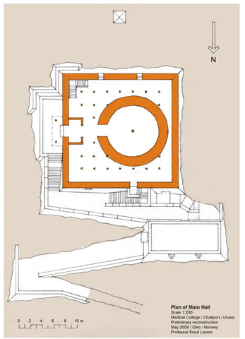
*Image 17: "Preliminary Reconstruction of the Yao Wang Mountain: Main Hall Plan"
Drawn by Knud Larsen in 2009

